

Category
What Is a Derecho? (And What Iowa Homeowners Should Do After One Hits)
9 minute Read

Posted 9.10.26

If you have lived in Iowa for more than a season, you already know how quickly a calm afternoon can turn violent. A derecho is one of the most destructive storm systems to sweep across the Midwest, producing a wind damage swath of straight line wind damage that can stretch hundreds of miles in a single afternoon, with wind gusts powerful enough to rival a hurricane. For homeowners in Cedar Rapids and surrounding areas, understanding what this kind of storm does to a home matters just as much as watching the radar, which is exactly why so many families lean on a team that shows up when the wind finally settles once the skies clear.
Here is a quick look at what this guide covers:
- What actually separates a derecho from an ordinary thunderstorm
- The warning signs that show up on your roof, siding, and gutters
- The exact steps to take once the wind finally stops

Why Storm Awareness Protects More Than Your Roof
Iowa sits inside a stretch of the Corn Belt where severe thunderstorms and derecho storms commonly occur, often strengthening into damaging high winds with only a short lead time from the Storm Prediction Center. Knowing why these storms deserve your attention before the next line of clouds builds on the horizon can save you thousands of dollars in avoidable repairs.
- Faster Onset: Derechos can strengthen from a line of ordinary storms into a damaging wind event in under an hour.
- Wider Reach: Unlike a single storm cell, the damage path often stretches across several counties at once.
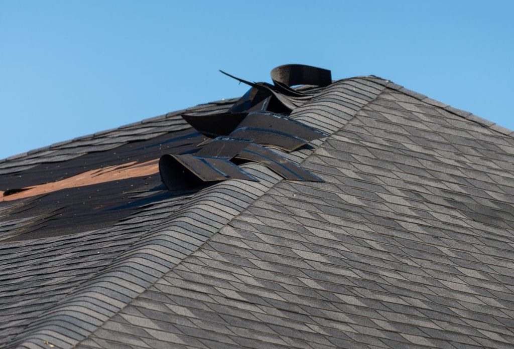
- Hidden Damage: Torn flashing, lifted shingles, and water intrusion from heavy rains are not always visible from the ground, which is part of why assessing the damage the right way matters before small issues turn into expensive ones.
- Insurance Deadlines: Many policies require storm damage to be reported within a set window of time.
Because these storms move fast and sometimes strike overnight, many homeowners do not realize the extent of the damage until weeks later, when a small leak turns into a water stained ceiling. Understanding the risk now can make recovery faster whenever the next severe storm watch fills the forecast.
6 Steps to Take Once a Derecho Passes Through Your Property
Once the wind dies down and the sky clears, the real work begins. Following a clear sequence of steps in the hours and days after a derecho can protect both your home and your insurance claim.
1. Wait Until It Is Actually Safe to Go Outside
Downed power lines, falling trees, and debris scattered by straight line winds can pose serious risks right after a storm passes. Give it time before stepping outside, and watch local news in case a trailing gust front or additional storms follow behind the main line.
2. Walk the Perimeter and Document Everything
Once it is safe, take a slow walk around your home and look up at each roof slope from a few different angles.
- Photograph missing, curled, or lifted shingles
- Note any dents, cracks, or displaced flashing
- Capture images of fallen branches, damaged siding, or bent gutters
Good documentation now will make the insurance process much smoother later.
3. Check the Attic for Hidden Leaks
Some of the most telling signs of derecho damage show up inside the home rather than outside. Grab a flashlight and look for water stains, damp insulation, or daylight coming through the roof deck where it should not be.
4. Contact Your Insurance Company Promptly
Most homeowner policies expect storm damage to be reported within a specific window, so it pays to make the call sooner rather than later. Having your photos ready when you file will speed up the entire process.
5. Schedule a Full Property Inspection
A trained eye can catch damage that is easy to miss from the ground, especially along the roofline and behind gutters. Many local roofing companies, including ours, offer a free full property inspection so you can understand the scope of the damage before committing to any repairs.
6. Avoid Storm Chasers and Verify Credentials
After a major storm, out of town crews often show up during recovery efforts offering fast, cheap repairs. Before signing anything, confirm that a contractor is OSHA certified, BBB accredited, and backed by manufacturers you actually recognize.
Families across Cedar Rapids and surrounding areas who follow these steps in order tend to have a much smoother experience with both their insurance carrier and their contractor. Skipping ahead, especially the documentation step, is one of the most common reasons claims get delayed or denied.
Understanding the Science Behind a Derecho
A derecho is not simply a strong thunderstorm. It is a specific type of weather event with its own history, its own measurable criteria, and its own place in Iowa’s storm records.
Where the Word Actually Comes From
The term derecho was coined in the late 1800s by a scientist at the University of Iowa, who borrowed the word from Spanish to describe a storm moving in a straight line rather than spinning like a tornado. That straight line path is exactly what makes these storms capable of damaging such a wide swath of land in a short amount of time.
How Derecho Winds Compare to Other Storms
The Storm Prediction Center classifies a derecho as a long lived line of thunderstorms, or mesoscale convective system, that includes wind gusts of at least 58 mph along a damage path stretching 250 miles or more. These storms typically form when warm, moist air near the surface meets strong winds aloft, often along a nearly stationary front in hot, humid conditions, and they usually show a telltale bow echo shape on radar. Most derechos across Iowa and the surrounding Corn Belt develop between April and August, peaking in May and June.
Iowa’s Most Notable Recent Derecho
On August 10, 2020, a derecho tore across central Iowa with wind gusts as high as 112 miles per hour in parts of the state. The storm knocked out power to more than a million homes and businesses across Iowa, Illinois, and Indiana, damaged an estimated 10 million acres of Iowa cropland in the heart of the Corn Belt, and became one of the costliest thunderstorm events in United States history, with damage estimates reaching roughly 11 billion dollars. That single afternoon reshaped how many Iowa homeowners think about storm preparedness.
Derecho vs. Other Iowa Storm Threats
Iowa homeowners deal with more than one kind of severe weather each year, and it helps to know how a derecho stacks up against the others. Each storm type behaves differently, which changes both the warning signs to watch for and the type of damage you are likely to see afterward.
| Storm Type | Wind Pattern | Typical Damage Path | Warning Time |
| Derecho | Straight line, sustained | Hundreds of miles wide | Minutes to about an hour |
| Tornado | Rotating funnel | Narrow, often under a mile wide | Minutes |
| Standard Thunderstorm | Localized gusts | A few blocks to a few miles | Usually hours |
Understanding these differences is not just trivia. A rotating storm calls for shelter in the lowest, most interior part of your home, while a derecho’s straight line winds put the entire structure under sustained pressure for a longer stretch of time. Knowing which threat you face before such events strike helps you react appropriately rather than guessing.

Frequently Asked Questions About Derecho and Thunderstorm Damage in Iowa
Storm damage raises a lot of questions, especially the first time you experience a derecho firsthand. Here are answers to the ones we hear most often from homeowners in Cedar Rapids and surrounding areas.
Is a Derecho the Same as a Tornado?
No. A tornado is a rotating column of air, while a derecho produces straight line winds that travel in one direction across a wide area. Both can cause severe damage, but the pattern of destruction looks very different on the ground.
How Long Does a Derecho Typically Last?
An individual derecho event can last several hours as it travels across a region, though any single location may only experience the strongest winds for 30 to 60 minutes.
Can a Derecho Cause Roof Damage Even Without Hail?
Yes. Straight line winds alone can lift shingles, tear off ridge caps, and loosen flashing, even without hail. Wind driven rain can also work its way under compromised shingles and cause leaks that are not obvious right away. Securing loose outdoor items before storm season and keeping a basic emergency kit on hand are simple ways to reduce risk in mobile homes and site built homes alike.
Will My Homeowners Insurance Cover Derecho Damage?
Most standard homeowners policies cover wind damage from severe storms, including derechos, but coverage details vary by provider and policy. It is worth reviewing your specific policy or asking your agent directly so you know what to expect before filing a claim.
How Soon Should I Get My Roof Inspected After a Storm?
Scheduling an inspection within a few days of the storm is a good general rule, especially if you notice any warning signs from the ground. Acting quickly also helps you stay within most insurance reporting windows.
If your home experienced a derecho and you are still unsure what to do next, you do not have to figure it out alone. A short conversation with a local expert can clear up most of the uncertainty in a single visit.
Let’s Get Your Home Back to Solid Ground
Derechos are unpredictable, fast moving, and capable of causing serious damage in a matter of minutes, but you do not have to face the aftermath alone. First Fruits Construction has spent years helping families here in Cedar Rapids and surrounding areas recover from severe storms with honest guidance and steady craftsmanship every step of the way. If you noticed any signs of damage after the last storm, or you just want an expert set of eyes on your roof before the next one arrives, contact us today and let’s get your home back to solid ground.

Discover Better Roofing Today!
"*" indicates required fields
"Whatever you do, work at it with all your heart"
Colossians 3:23